
What does honoring state history, and facilitating the in person visitor experience look like for Texas State Cemetery?
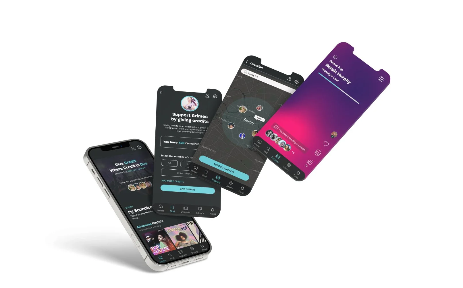
Successfully designed a modern, accessible government website and specialized interactive map tool for 3,200 burials and thousands of visitors annually.
I set the UX vision for this project and led the team with minimal day-to-day oversight from agency leadership.
- Sole UX lead — full ownership of research strategy, IA, and design direction
- Defined the overarching UX and functional vision for how a modern, responsive, and accessible interactive map would integrate with standard CMS pages.
- Owned all client-facing presentations and stakeholder sessions
The agency needed to digitize its massive, complex physical grounds into a modern, engaging tool. It wasn't just about a website refresh; it was about translating the physical legacy and historical data of the cemetery into an accessible, historical, and educational digital experience. The new website also had to take into account reserving plots, mapping new areas that the cemetery will expand into and multilayer plots.
Navigating state government hierarchies and collaborating tightly with a specialized cross-functional team (including Front-End and specialized Map Developers).
"Design a modern, accessible government website and specialized interactive map tool"
State government stakeholders and internal cross-functional teams (including GIS/Map developers).
Adapted standard CMS discovery methods to account for complex, custom spatial data integration alongside standard government pages.
Synthesis approach: Mapped the physical layout and historical data of the cemetery to digital equivalents, transforming a massive content audit into specialized functional specifications for an interactive map.
Research revealed the UX disconnect between the monolithic mapping software and standard public-facing historical content, driving the need for a unified digital experience.
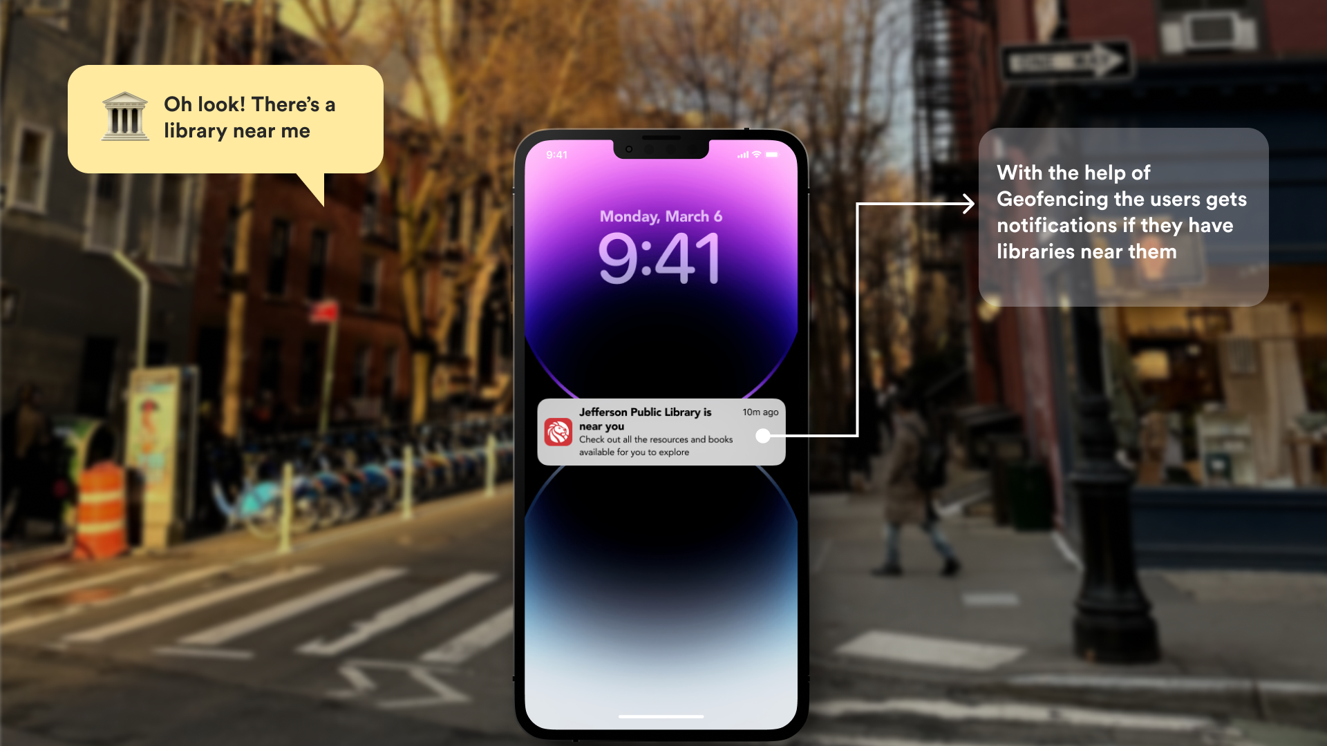
Designed a multi-layered digital ecosystem integrating a complex, interactive cemetery map with standard state government CMS pages. Designed a responsive system for genealogical research and in person wayfinding system for visitors.
Sitemapping
[Annotate: what this tested, what you learned from it]
Structured the content to bridge the physical-to-digital gap. I created an architecture that allowed users to seamlessly pivot between reading high-level historical narratives (e.g., biographies of prominent Texans) and locating their exact physical monuments via the interactive spatial map. The ux design consolidated both the factual historical experience and the personal history of the plot holder.
The highly specialized nature of the map required deep collaboration. I partnered directly with the Front-End Developer and a specialized Map/CMS Developer to ensure the UX vision was technically viable within the state's backend constraints.As a state agency, strict WCAG compliance was non-negotiable. I ensured all map interactions, spatial data filtering, and layout choices were fundamentally designed for screen-reader compatibility and keyboard navigation.
About - Historical Page
Map wireframes
Map Visual Designs
I directly guided the Visual Designer and Front-End Developer by providing detailed wireframes (across three distinct batches) and an annotated sitemap, giving them a rigid structural blueprint to execute their specialized work.
There was no existing playbook for integrating this specific proprietary map software into the Texas State Preservation Board’s broader digital ecosystem. I made the unilateral judgment on how to architect the data flow and user journey to ensure the map felt native to the site rather than a disjointed, third-party widget.
- What would not have happened without me — The seamless digital translation of physical cemetery grounds into a highly functional, accessible online experience. Without my autonomous direction of the UX phase, the intricate relationship between the standard CMS pages and the interactive spatial map would not have been established.
- Original framework or model I developed — I developed the Interactive Map Functional Specifications, a complex framework that mapped the physical, spatial constraints of a historic government site to strict digital and accessible requirements. This functional specifications allows for collaboration with the client to solidify the exact functionality of the new website in easy to understand language.
- Approach I pioneered at the agency — Collaborating with the client with design worksheets to faciliate feedback on designs.
- Domain expertise applied — Government CMS digital architecture, WCAG accessibility for complex interactions, and spatial/historical data UX.
Before: A system that wasn't fully serving audiences and causing internal staff issues.
After: Transformed a rigid, 25 year old physical-only cemetery mapping system into a fully responsive, digitally accessible mapping tool integrated seamlessly into a modern CMS
[Describe the business or mission impact — not just UX metrics. How many end users now benefit from this experience? What organizational goal did the redesign serve? Connect your design decisions to downstream outcomes.]
- Downstream reach — Modernized the digital infrastructure for a historic state government agency under the Texas State Preservation Board, directly impacting how millions of Texas citizens and educators access state history and prominent biographies.
- Business outcome — Delivered a massive end-to-end digital transformation and interactive map build, successfully steering 1,550+ project hours (across UX, Design, and separate FE/BE developers) to completion
- Accessibility — Ensured the highly complex, custom interactive cemetery map adhered to strict state government accessibility and ADA compliance standards.
Direct quote or testimonial from client lead / executive director
Was this engagement renewed or expanded? Implicit validation.
Board / leadership / conference — who attended and their seniority
Presentating three batches of wireframes and functional specifications to the Texas State Preservation Board stakeholders.
Because this project heavily involved an interactive map component, I would push to establish technical scoping boundaries even earlier in the discovery phase. Integrating proprietary map tools alongside a standard CMS requires a highly unified front-end and back-end vision.
What this changed in my practice
Managing 1,550+ project hours across completely different disciplines (Visual Design, Front-End, and Backend/Map Developers) taught me that a UX Designer cannot just hand off wireframes and walk away. I learned to treat functional specifications as living documents that bridge the gap between design intent and spatial data reality. This project cemented my framework for "Physical-to-Digital Content Modeling." When working with physical institutions (like cemeteries or museums), I now automatically include a phase dedicated to mapping physical geography to digital information architecture.
Thank you for looking through my work!
More projects are right here >>